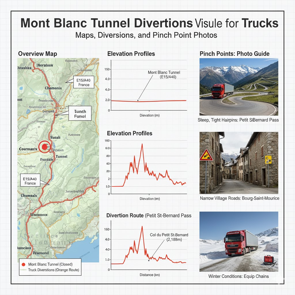
Introduction to Mont Blanc Tunnel and Its Significance for Truck Transport
The Mont Blanc Tunnel is a single-tube, two-lane highway tunnel under the Alps linking Chamonix (FR) with Courmayeur (IT). At 11.6 km, it’s one of Europe’s key trans-Alpine truck routes, carrying both passenger and freight traffic; its crown sits around 1,395 m above sea level, with the French portal near 1,274 m. For long-haul truck transit between France/Benelux and northwest Italy, this corridor shortens trips by dozens of kilometers and concentrates tunnel traffic flow through a single choke point—so when closures or diversions hit, planning matters.
Understanding Tunnel Diversions and Their Impact on Truck Routes
Common Causes of Diversions in Mont Blanc Tunnel
- Planned renovation/maintenance windows (vault, slab, drills).
- Unplanned incidents (vehicle fires, breakdowns) triggering temporary closure.
- Weather and avalanche control on the approaches.
- Regulatory constraints (ADR/dangerous goods bans; lane restrictions; HGV bans on certain dates).
Historical Overview of Major Diversions and Their Effects
- Long closures followed the 1999 fire (tunnel modernized, reopened in 2002).
- In recent years, autumn renovation campaigns have imposed multi-week full closures, shifting heavy freight to Fréjus and, secondarily, to Great St Bernard—creating tunnel congestion and bottlenecks on feeder motorways. Always verify current schedules before dispatch.
Detailed Maps of Mont Blanc Tunnel Diversions
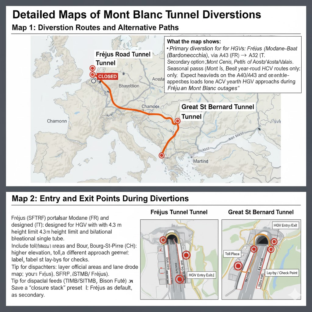
Map 1: Diversion Routes and Alternative Paths
What the map shows (use as your legend):
- Primary diversion for HGVs: Fréjus Road Tunnel (Modane–Bardonecchia), via A43 (FR) ↔ A32 (IT).
- Secondary option: Great St Bernard Tunnel (Martigny–Aosta) for flows north of Aosta/Valais.
- Seasonal passes (Mont Cenis, Petit St Bernard) are not year-round HGV options; treat as tourist/LCV routes only.
- Expect heavier loads on the A40/A43 and A5/A32 approaches during Mont Blanc outages.
Map 2: Entry and Exit Points During Diversions
- Fréjus (SFTRF) portals near Modane (FR) and Bardonecchia (IT); designed for HGV with 4.3 m height limit and bi-directional single tube.
- Great St Bernard portals near Bourg-St-Pierre (CH) and St-Rhémy (IT); higher elevation, toll, and different approach geometry.
Include toll-plaza pinch areas and lane drops on your annotated map; label safe lay-bys for checks.
Tip for dispatchers: layer official feeds (TMB/ATMB/SITMB, SFTRF Fréjus, Bison Futé) on your route map. Save a “closure stack” preset: Fréjus as default, Gd-St-Bernard as secondary.
Elevation Profiles of Mont Blanc Tunnel and Surrounding Areas
Profile 1: Elevation Changes Within the Tunnel
- French portal: ~1,274 m → gentle climb to crown ~1,395 m → gentle descent toward Italy.
- The profile is a subtle inverted “V,” aiding ventilation and drainage; gradients are mild but noticeable for heavy loads.
(Use a simple line chart: distance (km) on X, elevation (m) on Y; label “Chamonix portal,” “crown,” “Courmayeur portal.”)
Profile 2: Elevation Variations on Alternative Routes
- Fréjus: portals at broadly similar elevations (~1.2–1.3 km ASL), mild longitudinal grade—driver-friendly for winter freight.
- Great St Bernard Tunnel: higher portals (~1.88–1.92 km ASL) with avalanche galleries on approaches—plan engine-brake and coolant temps accordingly.
(Plot two comparative mini-profiles beneath the Mont Blanc line; note steeper approaches on Gd-St-Bernard.)
Identifying and Navigating Pinch Points in Mont Blanc Tunnel
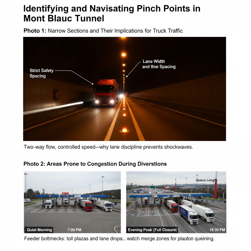
Photo 1: Narrow Sections and Their Implications for Truck Traffic
- Single tube, two-way traffic means no overtaking, strict spacing, and speed caps inside the bore.
- Editorial photo brief: show lane width, centerline beacons, and a tractor-trailer at legal spacing for a sense of scale.
- Caption idea: “Two-way flow, controlled speed—why lane discipline prevents shockwaves.”
Photo 2: Areas Prone to Congestion During Diversions
- Feeder bottlenecks: toll plazas and lane drops on the A40/RN205 (FR) and A5 ramps near Courmayeur (IT); on diversion days, watch merge zones to/from A43 (FR) and A32 (IT) for platoon queuing.
- Editorial photo brief: long lens of queueing HGV at toll/merge with timestamp; annotate “queue length” and “platoon release.”
- Add side-by-side crops of a quiet morning vs. evening peak during a full closure window.
Strategies for Truck Drivers to Manage Diversions Effectively
Pre-Trip Planning and Route Selection
- Pick your tunnel early. For Mont Blanc closures, route default to Fréjus; reserve Great St Bernard for northern flows and only if your tunnel regulations (height/ADR) fit.
- Axle weight & temps: Higher alt routes mean longer climbs; plan fuel, coolant, and brake temps—especially with full loads.
- Time-of-day strategy: Fréjus operator publishes guidance on most fluid times; shift departures to off-peak when possible.
Real-Time Navigation Tools and Updates
- Official ops: TMB / ATMB / SITMB alerts and the TMB Mobility app for tunnel real-time updates (closures, alternating traffic, drills).
- France network: Bison Futé work calendars with tunnel maintenance timetables and signed alternative paths.
- Frejus operator (SFTRF): HGV calendars, hazard advisories.
- Layer these with your ELD/telematics dashboard for dispatcher-to-cab messaging.
Safety Precautions and Compliance with Diversion Protocols
- Inside the bore: No overtaking, strict spacing, speed control, ADR compliance.
- Approaches: Expect tunnel safety measures—checkpoints, lane drops, and patrol vehicles.
- ADR/dangerous goods: Some loads are forbidden in Mont Blanc; check class-by-class rules before dispatch (don’t assume parity with Fréjus).
- Contingency: Carry printed detour cards for drivers; pre-brief on tunnel navigation tools if cellular data drops.
Conclusion: Enhancing Truck Transit Through Mont Blanc Tunnel Diversions
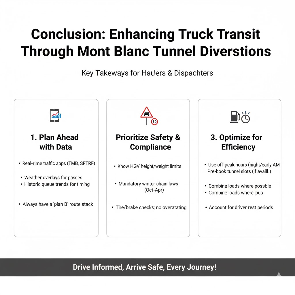
Diversions around the Mont Blanc Tunnel don’t have to wreck schedules. Treat them like high-alpine logistics: pick the right bore (Fréjus first for heavy freight), understand your elevation profiles and pinch points, and subscribe to official tunnel maps/tunnel real-time updates before wheels turn. With a pre-wired plan—maps annotated, elevation in mind, and photo-verified choke points—truck navigation stays predictable and tunnel safety stays front-of-mind for every run.
Visual bundle you can publish (per our site profile)
- Map 1 (Diversions): Fréjus and Great St Bernard highlighted; legend blocks for HGV-friendly vs seasonal.
- Map 2 (Access): Toll plazas, ramps, merge zones annotated.
- Profile 1 (Mont Blanc): 0–11.6 km line with 1,274 m (FR) → 1,395 m crown.
- Profile 2 (Alternatives): Side-by-side Fréjus (lower, milder grade) vs Great St Bernard (higher portals).
- Photo Set: Pinch-point pairs (quiet vs peak), toll/merge sequences, avalanche gallery approaches. Include descriptive alt text and date/time captions.
Planning longer alpine lanes or seasonal detours for freight? This explainer pairs well with route-planning briefs and load-securement checklists for multi-day runs.
Sources & operator references: Mont Blanc Tunnel facts & safety (GEIE TMB); official renovation/work calendars (Bison Futé); Fréjus operator (SFTRF) and HGV docs; closure/diversion notices for 2025.
Always verify live restrictions, ADR allowances, and closure calendars before dispatch; alpine operations are time-sensitive and subject to change.
Leave a Reply